Downloads & Manuals
Need help with your product?
Our Help & Support area contains articles and videos to help you get the most from your product.
SKU: 000-12528-001
000-12528-001IMO Type Approval
The Simrad MARIS ECDIS900 is IMO type approved/IEC61174:2008 Ed3 compliant for use on all SOLAS ships and other vessels that must carry an Electronic Chart Display and Information System under the ECDIS Carriage Mandate. Under SOLAS amendments all existing large passenger, tanker, and cargo ships will be obliged to fit ECDIS on a rolling timetable that began in July 2012 and ends in July 2018. All new passenger ships over 500gt, tankers over 3,000gt, and cargo ships over 3,000gt are required to carry an ECIDS system.
The ECDIS900 is also designed to comply with additional regulations set by Flag States, Port State Control, and the OCIMF Ship Inspection Report Programme (SIRE).
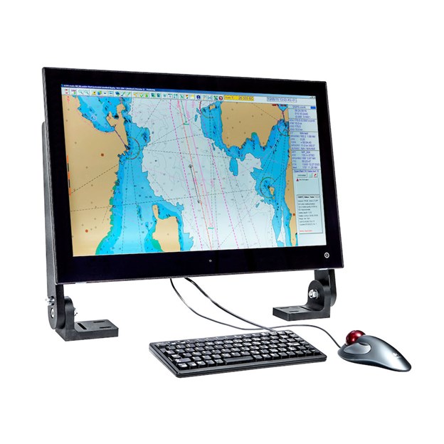
All-in-One PC Solution
The ECDIS900 MK15 includes a 24-inch ‘all-in-one’ flat panel display with integrated Windows PC, suitable for pedestal, table or flush-mount installation. The single-unit design, including four integrated NMEA0183 ports, dual Ethernet ports, and AC/DC power supply, allows for simple installation in a variety of locations, including consoles or tables with limited space where a separate display and ECDIS processor may prove impractical.
Easy to Use
Based on a standard Windows interface using common controls including toolbars, tabbed panels, hotkeys, and right-click context or ‘pop-up’ menus, the ECDIS900 is quick to learn and easy to use. All ECDIS900 models include a standard keyboard and trackball, for fast and accurate data entry.
Advanced Route Planning and Optimisation
The ECDIS900 offers powerful route planning tools, with integrated Voyage Decision Support (VDS) for route optimisation.
Voyage Decision Support assists navigators in selecting a route most likely to provide an on-time arrival, avoid poor weather conditions, and optimise fuel consumption. Taking into consideration detailed ship information and both current and forecasted weather, VDS evaluates multiple route options and highlights the risks and benefits of each. The user may then select and begin navigation of the preferred route.
The ECDIS900’s Search And Rescue (SAR) module automatically creates drift-compensated routes for search patterns, including Expanding Square, Sector, and Parallel Tracks.
Precise Navigation Tools
The ECDIS900 offers tools to facilitate safe and precise navigation, including position prediction and docking assistance.
The Predictor module calculates future ship positions based on GPS, gyro, speed and course data, and displays the full ship’s outline extended forward in time. In narrow waters, this provides an accurate visual representation of the entire ship’s position throughout turns – allowing the navigator to optimise speed and rate of turn accordingly.
The Docking module helps to facilitate safe docking manoeuvres by calculating and clearly displaying the ship’s distance and approach speed to both bow and stern docking points. During docking the ship’s current, historical, and predicted future positions are also displayed graphically on the current chart.
Logbook
The ECDIS900 includes a digital ship’s logbook, which automatically records all navigation events during a voyage. Logbook entries for any selected day can be replayed, displaying settings, charts, and events on the ECDIS screen as they originally occurred. Events and data logged include:Ship’s position
AIS and radar targets
ENC in use/chart status
Centre of the screen
Active route and waypoint
All alarms and acknowledgements
Ship’s settings (draft, safety contour, etc)
Manually plotted positions and Lines Of Position (LOPs)
All Navigation Editor objectsRadar Overlay
The image from a connected radar may be displayed on the ECDIS900 as a chart layer, superimpos